Friday, November 22, 2019

2019 - Great Smoky Mountains National Park Trip

We went on a self hiking trip to visit the Great Smoky Mountains National Park.  It was just two of us for a week and we planned this one to be a relaxing and leisure trip. 

We flew in to Atlanta via SW and stayed in Cherokee, North Carolina for the whole week from Nov 6 to Nov 12.  We found a hotel which is just 4 minutes drive from the national park entrance as our base, and we drove in/out to visit different parts of the park for hiking.  According to the official web side of US National Parks, there are 5 most popular destination hikes in this park:
  • Charlies Bunion
  • Alum Cave Bluffs
  • Andrews Bald
  • Rainbow Falls
  • Chimney Tops
We had 6 full days to visit this park. So happen, one of the 6 days was raining, therefore, we utilized the remaining 5 sunny days to hike all 5 trails.  It was a fun and relaxing trip. 

The itinerary were as the following:
  1. Tuesday, November 5, 2019 - flew to Atlanta, and drove to Cherokee, NC
  2. Wednesday, November, 2019 - hiked on Andrew Bald Trail
  3. Thursday, November 7, 2019 - visited Cades Cove area
  4. Friday, November 8, 2019 - hiked on Alum Cave Trail
  5. Saturday, November 9, 2019 - hiked on Chimney Tops Trail
  6. Sunday, November 10, 2019 - hiked on Rainbow Falls Trail
  7. Monday, November 11, 2019 - hiked on Charlies Bunion Trail
  8. Tuesday, November 12 - drove to Atlanta and flew back to Houston
It was the fall foliage time and we had an opportunity to view changing colors of leaves and also experienced cold weather.  It was fun and refreshing to visit these mountains. Some highlights are as the following:
Great Smoky Mountains from Oconaluftee Valley Overlook
View from the top of Observation Tower
View from Maloney Point Overlook
Great Smoky Mountains with Fall Foliage
View of Chimney Rocks from distance
Fall foliage on the Deep Creek Loop Trail
Alum Cave Bluffs
Rainbow Falls
Panoramic view of Charlies Bunion

Tuesday, November 5, 2019 -flew to Atlanta, and drove to Cherokee, NC

It was a traveling day without any particular event.  After we got the rental car, we drove from Atlanta to Cherokee which was about 3 1/2 hours.  Since it was the end of summer day light saving time, the sky got dark pretty quickly after 5:30PM.  We arrived at Cherokee without any issues and checked into Baymont Hotel by Wyndham Cherokee Smoky Mountains.  Everything was smooth.

Wednesday, November 6, 2019 - hiked on Andrew Bald Trail

It was a short (about 4 minutes) drive from our hotel to enter the Great Smoky Mountains National Park. Our 1st stop was the place with the Great Smoky Mountains National Park sign.  We took photos at this spot. Then, we drove to Oconaluftee Visitor Center to get information regarding hiking trails in this national park.  They did have a nice map to show trails including Andrew Bald Trail.

The Great Smoky Mountains National Park sign
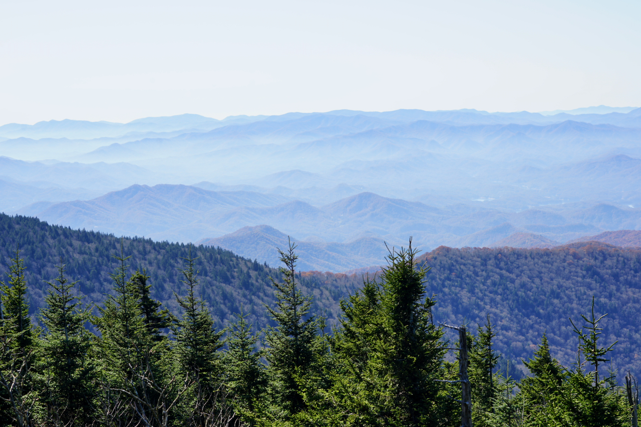
The route to the trail head of Andrew Bald Trail is a major road between NC and Tennessee. The road is very curly and have a lot of traffic. Therefor, it took us about 1 hour to get there.  On the way, we stopped several places to take photos of the Great Smoky Mountains and it’s fall foliage. The Smokies are named for the blue mist that always seems to hover around the peaks and valleys. The Cherokee called them shaconage, (shah-con-ah-jey) or “place of the blue smoke”. From one of the overlook site, we can view it clearly and understand why it is called smoky.
Smoke on top of Great Smoky Mountains
After we got to the trail head of Andrew Bald Trail, we had to circle around to find a parking spot.  We were lucky to find one right away.  

The first itinerary item was hiking up to the observation tower at the top of Clingmans Dome.  At 6,643 feet, Clingmans Dome is the highest point in the Great Smoky Mountains National Park. It is the highest point in Tennessee, and the third highest mountain east of the Mississippi. The observation tower on the summit of Clingmans Dome offers spectacular 360° views of the Smokies and beyond for visitors willing to climb the steep half-mile walk to the tower at the top. 
Observation Tower
After we got back to the parking lot, it took us a little effort to find the start point of Andrew Bald Trail.  It is a 3.5 miles round trip, 899 ft elevation gain trail with difficulty rating of 5.30.

Once we got on the trail, we found this is a very well maintained trail with up/down and clear marked trail.  For someone likes to hike, this is a very nice trail.  It offers variety of ups and downs, and the forest along the trail is beautiful.  With the fall foliage, it offers even more beautiful sceneries.  It took us about one hour to hike up to the top along with many photo stops.
Well Maintained Andrew Bald Trail
0.7 miles to Andrew Bald
After we got onto the top, we found a flat area on the top of the hill.  With trees around it, there isn’t much of WOW factors to reward you for the long hike as we did,  It was sort of a disappointment at the end point.  However, we still like the hiking trail very much. 
 On the  top of Andrew Bald
When we got down back to the trail head, it was about 2:40pm, therefore we just headed back to Cherokee.  On the way passing the Oconaluftee Visitor Center, we found a lot of elks eating grass in the field next to the road.  We stopped like many other visitors and took quite a few of pictures.
Elks by the field next to Oconaluftee Visitor Center
Male Elk
Elks by the field next to Oconaluftee Visitor Center

Thursday, November 7, 2019 - visited Cades Cove area

According to weather forecasting, it will rain in the afternoon. Therefore, we decided to visit the Cades Cove area and drive through the Cades Cove Loop Road.  Supposedly, it is the area with most chance of viewing wild animals.  It is about 2 hours drive from our hotel.  

On our way, we have to pass the Newfound Gap where there is a huge parking lot and the site of Rockefeller Memorial. The scenic views from this large parking area are breathtaking.  
View from the Newfound Gap parking lot
This is also the state border line of North Carolina and Tennessee.  
State border line between North Carolina and Tennessee
Rockefeller Memorial is just next to the state border line on the Tennessee side. It honors the $5 million donation from the Rockefeller Foundation to help complete land acquisitions to bring about the creation of the Great Smoky Mountains National Park.  We spent sometime there for photos and relaxing.
Stair way of the Rockefeller Memorial
The park on top of Rockefeller Memorial
When we were at the Sugarlands Visitor Center, we got a recommendation from the ranger to hike on the Cove Mountain Trail to visit Cataract Falls, and to hike on Fighting Creek Natural Trial to visit John Ownby Cabin. Both of them are easy trail without too much exciting attractions, however, it was just right for us to get some hiking before the rain coming down in the afternoon,

Cataract Falls 
John Ownby Cabin
On our way to Cades Cove, we had to drive on the Little River Road for about 1 hour.  It is built along the Little River with beautiful fall foliage on both sides. Tennessee side of the park is much prettier than the North Carolina side of the park.  We stopped several times to enjoy it.
Fall foliage along the Little River Road
Fall foliage along the Little River Road 
Fall foliage along the Little River Road
When we got to the Cades Cove, it was raining already.  Therefore, we could only drive along the Cades Cove Loop.  With the rain, the only animals we saw were horses at the beginning of the loop and few deers in the field.  We were told by rangers in the Cades Cove Visitor Center, there are about 45 black bears here which is the most concentrated area of black bears in the Great Smoky Mountains National Park (the whole park has about 1,500 black bears).
Horses in Cades Cove

Friday, November 8, 2019 - hiked on Alum Cave Trail

Sky cleared up in the morning, but it was cold with tempurture about 31F.  When we arrived at the visit center, the ranger told us the Newfound Gap Road was closed due to the weather.  Therefore, we had to change our plan to visit the Deep Creek area instead.  There is a Deep Creek Loop Trail which has 3 waterfalls, namely Juney Whank Falls, Indian Creek Falls and Toms Branch Falls. It is 4.6 miles with 579 ft elevation gain trail with difficulty rating of 5.76. 

We started at the left side of the trail and found Juney Whank Falls pretty quickly.
Juney Whank Falls
Then we turned to Deep Creek Horse Trail to the other side of the loop and found Indian Creek Falls and Toms Branch Falls.  The trail between Indian Creek Falls and Toms Branch Falls is a pretty wide and easy trail with beautiful fall foliage.  It was an enjoyable easy trail.
Deep Creek Loop Trail
Fall foliage on Deep Creek Loop Trail
Toms Branch Falls
Then the temperature rise to upper 30F and the Newfound Gap Road was opened, we decided to try the Alum Cave Trail.  Due to the Veterans Day long weekend, there were a lot to visitors and the trail head parking lot was totally full.  We had to park along the road to start our hike.  At that time, it was 37F.  The hiking trail is 4.4 miles round trip with elevation gain of 1125ft and the difficulty rating is 6.65.  However, we felt that it was easier than the Andrew Bald Trail.  There are two attractions on this trail namely Arch Rock and Alum Cave Bluffs.  Arch Rock is about 1.4 miles from the trail head and is a large concentration of black slate that formed a natural, arch-like shape over time. One will hike through the arch via a set of rock stairs and the assistance of cable handrails.
Need to use chain to help to climb up on the Alum Cave Trail
View of Arch Rock from the top
Alum Cave Trail near Alum Cave Bluffs
Alum Cave Bluffs which is not a cave, but rather a massive concave overhang that towers 75-80 feet high. This large area is a popular resting point for many hikers and it was our end point of this hiking trail.  When we got there, the sky cleared up with some cloud hanging in the middle of the mountains, it formed a beautiful scenery for pictures.  It did not last long and the cloud gathering all over the mountains about 20 minutes later.  We were so lucky to get to the top of Alum Cave Bluffs at the right time.
Breath taking scenery at Alum Cave Bluffs
At Alum Cave Bluffs
At Alum Cave Bluffs
At Alum Cave Bluffs
We had enough hiking at this point and decided to head back to town.  On the way back passing an overlooking point, we noticed the sunset lighting is just right for more photographing the Great Smoky Mountains, and we had to stop for it.
Beautiful fall foliage with sunset lighting

Saturday, November 9, 2019 - hiked on Chimney Tops Trail

Today’s goal was hiking on Chimney Tops Trail.  It is 3,3 miles round trip with elevation gain of 1487 ft and with difficulty rating of 6.27. The first half of the trail was moderate difficult, however the 2nd half of the trail was steeper with almost 1000 ft elevation gain. There are well built stairs and it is not difficult if one rest periodically.  The last portion of the trail is closed due to fire damage in nearby area, however some of younger hikers just climbed over the locked gate and climbed to the top of the rock pinnacles which known as Chimney Tops.  I also climbed over the locked gate just for a photo opportunity. 
Chimney Tops Trail
Chimney Tops Trai 
Chimney Tops Trail
Chimney Tops Trail
View of Chimney Tops (the rock pinnacles )
Behind the locked gate for photo opportunity
After we got back to Oconaluftee Visitor Center, we decided to make another hike on Oconaluftee River Trail which is a 3 miles round trip trail with 70 ft elevation gain and the difficult rating is 3.4.  The trail was built along the Oconaluftee River all the way to the boarder of the park and adjacent to the Cherokee town.  It was a pleasant and easy hike after the Chimney Tops trail.
Fall foliage on the Oconaluftee River Trail
When we got back to the filed next to Oconaluftee Visitor Center, there were a lot of elks eating grasses on the field. We did just like many other visitors and took lots of pictures.
More elk photo
More elk photo